How to Plan Your Drive from Guwahati to Tawang Without Altitude Sickness
Published
Reading time
5 min read

Driving from the plains of Guwahati to the high-alpine fortress of Tawang is one of the most legendary road trips in Asia. This route transforms from the flat banks of the Brahmaputra River into the snow-clad peaks of the Eastern Himalayas.
However, because Tawang sits at a high altitude of 3,048 meters (10,000 feet) and the road crosses the massive Sela Pass at 4,170 meters (13,700 feet), climbing too quickly can trigger Acute Mountain Sickness (AMS).
Altitude sickness is entirely preventable. By structuring your driving layout correctly, scheduling acclimatization stops in intermediate valleys, and following simple hydration rules, you can complete this mountain drive in total comfort. This long-form guide provides the exact itinerary layout, altitudinal milestones, and safety strategies needed for a flawless road trip.
🧭 The Altitude Profile: Guwahati to Tawang
To understand how to prevent mountain sickness, you must visualize the dramatic elevation jump across this road corridor.
[Guwahati: 55m] ──> [Dirang Valley: 1,560m] ──> [Sela Pass: 4,170m] ──> [Tawang Plateau: 3,048m]
The human body adapts beautifully to thin air if given time. Problems occur when travelers try to speed from Guwahati to Tawang in a single continuous drive. Climbing more than 3,000 meters in a day shocks the respiratory system, leading to headaches, dizziness, and nausea.
For a comprehensive safety overview of the state's driving corridors, view our guide on Is Arunachal Pradesh Safe to Travel?. If you prefer a fully managed vehicle loop with an experienced mountain driver, check out our Majestic Tawang Himalayan Escape 7-Day Tour.
Day 1: Guwahati to Dirang Valley
- Starting Altitude: 55 meters (180 feet)
- Ending Altitude: 1,560 meters (5,118 feet)
- Average Driving Time: 8 to 9 hours via the smooth Bhalukpong highway corridor
- Acclimatization Value: Excellent. Sleeping at 1,560 meters is the perfect baseline stage for your body. It allows your lungs to adjust without putting stress on your heart.
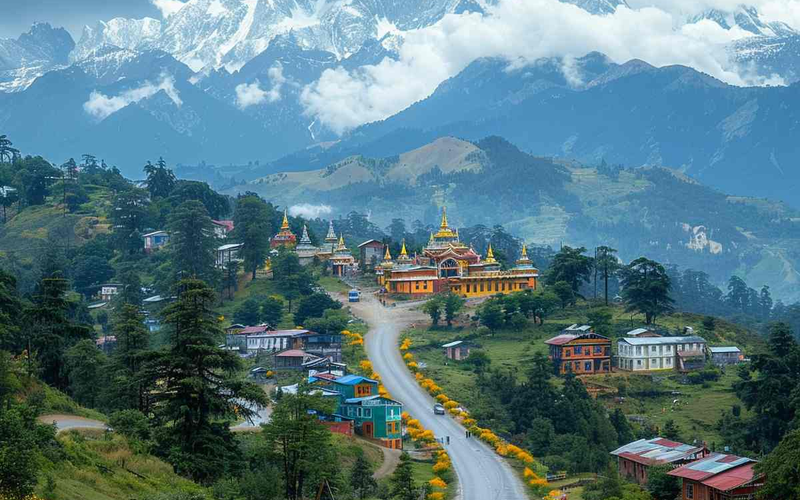
Instead of stopping your first night at Bomdila (which sits much higher at 2,414 meters), push slightly further down into the warm, fruit-orchard bowl of the Dirang valley. To look over everything there is to do in this intermediate stop, reference our Things to Do in Dirang Travel Guide.
Day 2: The Dirang Rest & Adaptation Day
- Altitude State: Steady at 1,560 meters
- The Strategy: Do not drive uphill today. Spend the morning walking slowly through the ancient stone lanes of Dirang Dzong or soaking your muscles in the natural sulfur currents of the local hot springs. This light physical activity helps oxygen circulate through your muscles.
To learn more about the thermal wellness benefits of this valley, see our dedicated Dirang Valley Hot Springs Healing Guide.
Day 3: Dirang to Tawang via Sela Pass
- Peak Altitude Hit: 4,170 meters (13,700 feet) at Sela Pass
- Night Stay Altitude: 3,048 meters (10,000 feet) in Tawang
- Average Driving Time: 5 to 6 hours
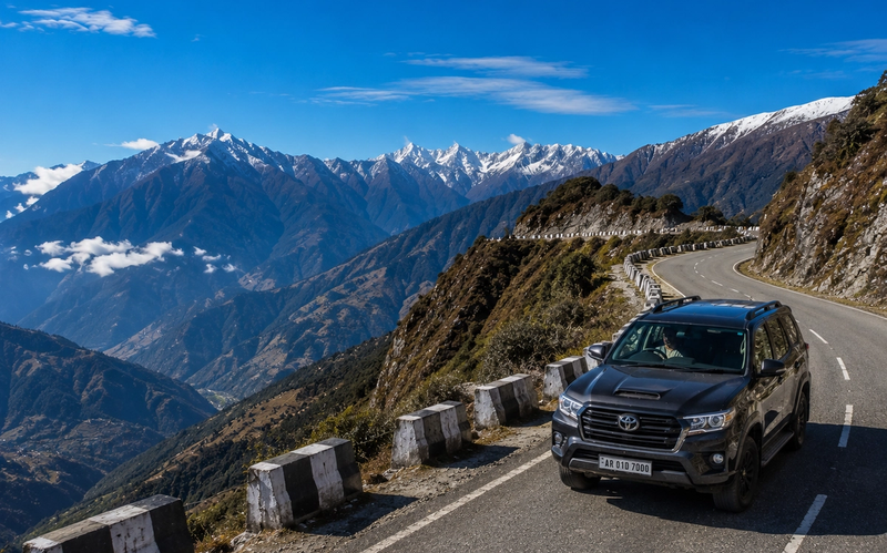
- The Strategy: Today, you will cross the highest point of the road trip. Because you spent two nights adapting in Dirang, your body can handle the thin air of Sela Pass comfortably for short photo breaks. Once you cross the pass, the road drops down onto the stable Tawang plateau.
⛰️ Crossing Sela Pass: The 30-Minute Safe-Zone Rule
Sela Pass is a breathtakingly beautiful mountain pass flanked by two deep blue alpine lakes. Because it sits at a high altitude of 4,170 meters, the air pressure here is significantly lower than at sea level.

The Golden Protocol for Sela Pass:
- Limit Your Exposure: Keep your sightseeing stop at the top of Sela Pass restricted to 30 minutes or less. This gives you plenty of time to take photos, view the prayer flags, and enjoy the snow without triggering high-altitude headaches.
- Avoid Sudden Exertion: Do not run, jump, or carry heavy bags rapidly at the pass. Move at a slow, deliberate walking pace.
- Keep the Vehicle Cabin Ventilated: If you are driving with the vehicle windows completely rolled up and the heater running at maximum, carbon dioxide builds up inside the car. Keep a window cracked slightly open to let fresh, oxygen-rich mountain air circulate.
To prepare for the dramatic weather changes along this high ridge, read the Sela Pass Travel Guide: Weather, Altitude, & Tips.
💧 Hydration, Diet, and Medical Preventatives
How you fuel your body during the long drive directly dictates how well your system handles changing atmospheric pressures.
1. The Power of Structured Hydration
Dehydration mimics and accelerates the symptoms of altitude sickness. The dry mountain air causes your lungs to expend moisture rapidly as you breathe.
- The Metric: Aim to drink 3 to 4 liters of clean water daily throughout the drive.
- The Formula: Mix standard Oral Rehydration Salts (ORS) or electrolyte powders into your water bottles. This helps your body retain essential minerals during the climb.
2. Mountain Carbohydrates vs. Heavy Fats
At high elevations, your digestive system slows down because your body prioritizes oxygen delivery to your heart, lungs, and legs.
- What to Eat: Focus your roadside lunches around light, easily digestible carbohydrates like steaming plates of local vegetable momos, clear noodle soups, rice, and lentil broths.
- What to Avoid: Skip heavy, deep-fried meats, oily paranthas, and processed cheeses during the ascending driving segments.
3. Medical Interventions: Proactive vs. Reactive
- Consult Your Doctor: Speak with your general physician before leaving Guwahati about carrying preventative medications like Acetazolamide (commonly known as Diamox).
- The Timing: If prescribed, preventative altitude medicines are typically started 24 hours before crossing into high-altitude zones (e.g., starting the dosage while resting in Dirang), rather than waiting until a severe headache begins.
🛠️ Choosing Your Vehicle and Packing Requirements
The highway link from Guwahati up to the Sela Pass is fully paved, but sudden mountain weather changes can introduce gravel, mud, and slush onto the higher mountain turns.
- The Ideal Choice: A high-clearance private SUV (such as an Innova, Scorpio, or Safari) is highly recommended. The robust suspension system absorbs the continuous highway bumps comfortably, reducing physical fatigue—which is a major hidden contributor to mountain sickness.
- Oxygen Cannister Kits: Carry a few portable, lightweight oxygen canisters (available at major pharmacies in Guwahati). Having a small bottle inside your car cabin provides instant relief and peace of mind if a family member feels faint near the top of the pass.
- Layered Clothing Separation: Do not pack your winter woolens inside your heavy suitcases at the back of the car trunk. Temperatures drop instantly as you climb. Keep a windproof jacket, gloves, and a warm woolen cap inside your day bag right next to your seat.

For a comprehensive packing checklist, look over our professional layout guide: What to Pack for an Arunachal Pradesh Trip.
🛈 Final Practical Tips for Your Road Trip
To ensure your journey from the valley to the high peaks goes flawlessly, keep these final logistical steps in mind:
- Secure Your Inner Line Permit (ILP) Early: All domestic travelers entering Arunachal Pradesh must carry a valid Inner Line Permit. Save time at the Bhalukpong border gate by securing your permit online beforehand. See our step-by-step Arunachal Pradesh ILP Online Guide.
- Track Seasonal Weather Shifts: Tawang features completely different highlights across the summer and winter months. Check out our comparative breakdown on the Tawang Winter vs. Summer: Best Time to Visit Guide to match your driving dates with clear highway visibility.
- Keep Cash on Hand: While major hotels in central Tawang accept digital smartphone payments, cellular signals can drop along remote mountain passes. Keep an ample supply of physical cash notes inside your glove compartment for vehicle toll fees and small roadside tea stalls.
🗺️ Expand Your Himalayan Travel Plans
Structuring a slow, safe drive lets you arrive in Tawang feeling energized and ready to explore its incredible landmarks—from the stunning lakeside paths of Madhuri Lake to the ancient, peaceful halls of the Tawang Monastery.
If you are currently drafting your full holiday loop from Assam across the mountain passes, read our complete road layout guide: How to Plan a Perfect 7-Day Tawang Road Trip from Guwahati.
Ready to experience the mountains without the stress of managing inner-line permits, organizing high-clearance SUVs, and tracking local mountain road openings? Head over to our Arunachal Pradesh Tour Packages page to explore our thoughtfully organized itineraries, or drop us a line directly via our Contact Us page. We will connect you with a local travel expert to design your custom Himalayan road trip today.

Helpful Answers
Frequently Asked Questions
Technically, a vehicle can complete the drive in 15 to 16 hours of continuous driving, but doing so is highly dangerous and strongly discouraged. This rapid ascent does not give your lungs time to adapt to the thin air, significantly increasing your risk of severe altitude sickness at Sela Pass. Always schedule a midpoint overnight stop in the Dirang Valley.
No. There are no active commercial railway stations or large airline terminals inside the high-altitude terrain of Tawang. Your closest major railway station and international airport hub is located back in Guwahati, Assam. The remaining mountain distance is completed via a scenic multi-day road drive.
Local Himalayan hot drinks, like traditional salted butter tea or fresh ginger-garlic broths, are fantastic for warming your body and staying hydrated along cold mountain curves. While they are great for comfort, they do not replace the fundamental need for gradual altitudinal ascent and proper hydration with water and electrolytes.
If someone feels dizzy or develops a sharp headache at the top of the pass, administer a portable oxygen canister session immediately, keep them warm, and prevent them from walking around. Do not linger at the pass. Immediately board your vehicle and drive down toward the lower, stable slopes of Tawang or Dirang, where the air pressure increases naturally.
Plan This Journey
Turn this Tawang guide into a trip that fits your pace
If this guide is part of the kind of holiday you want, Breeziah can help shape the route, travel flow and stay style around your dates, comfort level and destination priorities.
Related Guides
Continue exploring Tawang
12 Best Things to Do in Tawang: Unforgettable Himalayan Experiences
Discover the best things to do in Tawang, from monasteries and Sela Pass to waterfalls, lakes, and Himalayan adventures for unforgettable experiences.
How to Plan the Perfect 7-Day Tawang Road Trip from Guwahati
Planning a high-altitude road trip across the Eastern Himalayas requires a solid foundation of geographic reality and legal foresight. Winding from the plains of Assam to the sub-zero peaks of western Arunachal Pradesh, our ultimate 7-day Tawang road trip itinerary from Guwahati maps out an acclimatization-first overland corridor. Discover how to navigate switchback highways in a premium SUV, secure your online border permits effortlessly, and experience the deep spiritual stillness of Tawang Monastery and Bum La Pass. Skip the standard tourist blunders and plan a seamless, high-sensory expedition into the land of the Monpas.

Monpas of Tawang: A Beautiful Glimpse into Arunachal’s Buddhist Culture
Journey into the heart of the Eastern Himalayas. This definitive guide explores the Monpa people’s spiritual life, ancient crafts, and the "organic luxury" of Tawang’s traditional villages.