How to Plan the Perfect 7-Day Tawang Road Trip from Guwahati
Published
Reading time
5 min read

Quick Summary: The Definitive 2026 Eastern Himalayan Route Matrix
- The Core Journey: A masterfully orchestrated 7-day high-altitude overland expedition mapping out a seamless corridor from the plains of Assam to the sub-zero peaks of western Arunachal Pradesh.
- The 2026 Trending Focus: "Acclimatization-First Overlanding"—prioritizing precise altitude steps over aggressive driving, utilizing strategic valley rest stops to guarantee stress-free mountain transit.
- Primary Bottlenecks: Navigating mountain passes over $13,700\text{ feet}$ safely and executing real-time logistics for active boundary control permits.
- Strategic Base Nodes: Dirang Valley (for alpine orchard stabilization) and Tawang District (for high-sensory cultural and spiritual depth).
- Pro Tip: Always cross Sela Pass before 1:00 PM; late-afternoon solar shifts routinely create severe localized whiteout conditions and sharp black-ice formations.
1. The High-Altitude Matrix: Route Infrastructure
Planning an overland route up the spine of the Eastern Himalayas requires a solid foundation of geographic reality. You are scaling vertical terrain that climbs from near sea level in the Brahmaputra Valley to over $13,700\text{ feet}$ at the peak of the mountain highway. This 7-day flow is mathematically optimized to manage physiological elevation steps while keeping driving times under control:
| Day | Transit Corridor | Target Altitude | Key Geographic Milestone | Road Character |
|---|---|---|---|---|
| Day 1 | Guwahati → Bhalukpong | 700 ft | Entry into the Kameng River Gates | Broad National Highway |
| Day 2 | Bhalukpong → Dirang | 4,910 ft | Stabilization in the Apple Valleys | Winding Mountain Asphalt |
| Day 3 | Dirang → Tawang | 10,000 ft | Sela pass crossing(13,700ft | High-Altitude Ridge Switchbacks |
| Day 4 | Tawang District Loop | 10,000 ft | Monpa Spiritual Centers & Waterfalls | Local District Tracks |
| Day 5 | Tawang → Bum La Loop | 15,200 ft | Indo-China Border Control Frontier | Rugged Unpaved High-Alpine |
| Day 6 | Tawang → Bomdila | 7,920 ft | High-Altitude Reverse Transition | Continuous Ridge Descent |
| Day 7 | Bomdila → Guwahati | 180 ft | Final Descent into Assam Plains | Downward Switchbacks to Flat |
2. The Legal Foundation: Online ILP & Border Control
Arunachal Pradesh operates under a strict sovereign security system. You cannot simply board a vehicle and cross the border gates without valid documentation.
- The Inner Line Permit (ILP): Every domestic traveler requires an active Inner Line Permit to cross the state line at Bhalukpong. At BREEZIAH, our operational desk secures these via the state portal at least seven days before your departure.
- The Bum La Border Passes: Day 5 of this itinerary approaches the frontline international border. This requires secondary clearance from the Deputy Commissioner’s office in Tawang, paired with local army counter-signatures. Independent travelers frequently experience day-long operational delays here; booking via a structured agency streamlines this administrative protocol completely.
- Internal Link: Review the technical document parameters and verification criteria via our dedicated Arunachal Pradesh online ILP guide.
3. Day 1: The Escape from the Plains—Guwahati to Bhalukpong
Your expedition begins with a morning pickup from Guwahati airport. The initial segment of the road trip cuts smoothly across the flat floodplains of the Brahmaputra River via the broad national highway corridors of Assam.
[Guwahati Plains] ===> [Tezpur Highway Sector] ===> [Bhalukpong Assam-Arunachal Checkpost]
The Transition Zone
As you approach Tezpur and turn north toward the hills, the terrain shifts abruptly. The flat agricultural fields drop away, replaced by the rising foothills of the outer Himalayan wall. You will cross the formal state checkpost at Bhalukpong, verify your documents, and enter the deep, tropical forests of western Arunachal Pradesh.
The Kameng River Base
Day 1 ends at a riverside eco-lodge or comfortable resort in Bhalukpong. Here, at an altitude of just $700\text{ feet}$, you will sleep alongside the rushing waters of the Kameng River. Keep your phone tucked away; instead, acclimate your senses to the sounds of the dense mountain forest.

4. Day 2: Navigating the Apple Orchards—Bhalukpong to Dirang
Break camp at 7:30 AM to begin your formal ascent up the spine of the mountains, tracking the old trade route channels northward.
The Ascent Through Bomdila Pass
The road gains elevation steadily, wrapping around mountain ridges where bamboo groves give way to pine stands. You will cross the town of Bomdila, catching your first glimpse of the high snow peaks on the horizon. Don't linger too long at the high ridges yet; instead, descend directly into the protected microclimate of the Dirang Valley.
The Alpine Stabilization Phase
Dirang sits at an ideal intermediate altitude of $4,910\text{ feet}$. This valley serves as your critical step for acclimatization, preventing high-altitude sickness before you attempt the high passes tomorrow. Spend your afternoon wandering through old Monpa stone villages, walking through Kiwi and apple orchards, or relaxing by the natural hot springs along the river basin.
- Internal Link: Review our comprehensive list of local valley activities and cultural walks in our standalone guide on the best things to do in Dirang.
- Internal Link: Looking for elemental healing alternatives? Explore our Dirang Valley hot springs healing guide.

5. Day 3: Crossing the Frozen Portal—Sela Pass to Tawang
This is the most visually dramatic driving segment of your overland itinerary. Your vehicle will climb from the temperate climate of Dirang into a sub-zero, high-alpine ecosystem.
The Sela Pass Gateway( 13,700 ft )
As your private SUV approaches the tree line, the pine forests thin out into stark rock faces and patches of mountain snow. You will climb the switchbacks of the mountain highway to reach the majestic gateway of Sela Pass. The air here is thin and crisp. Take short, steady steps as you walk along the banks of the frozen Sela Lake, a high-altitude body of water that remains iced over for large parts of the winter season.
The Descent into the Tawang Valley
After crossing the pass and passing the historic war memorial at Jaswant Garh, the road drops down into the deep, sweeping bowl of the Tawang Valley. You will check into your premium mountain lodge or boutique homestay, wrap yourself in thick wool blankets, and adjust to the crisp evening air at $10,000\text{ feet}$.
- Internal Link: Study the exact microclimate details and seasonal weather behaviors of this route in our Sela Pass travel and weather guide.

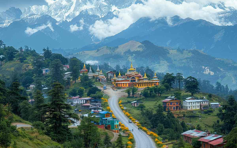
6. Day 4: Monasteries and Mist—The Monpa Cultural Core
Day 4 is dedicated to a slower, deep-immersion exploration of the unique culture and history of the indigenous Monpa clans.
[Tawang Base] ===> [Tawang Monastery] ===> [Chakzam Bridge] ===> [Giant Buddha Overlook]
The Fortress of Quiet: Tawang Monastery
Begin your morning at the historic Tawang Monastery (Ganden Namgyal Lhatse), the second-largest Buddhist monastery in the world. Founded in the 17th century, this massive, fortified complex houses ancient scriptures, gilded bronze statues, and an impressive three-story-tall Buddha image. Stand quietly in the central courtyard as the morning mists drift across the yellow rooftops, listening to the deep, resonant chanting of the resident Monpa monks.
Prehistoric Metallurgy: The Chakzam Bridge
In the afternoon, head further out into the valley to see the iron-chain suspension bridge at Chakzam. Built in the 15th century by the legendary builder Tangtong Gyalpo, this living engineering marvel utilizes hand-forged iron chain links that have stood firm against centuries of mountain weather—a prime example of ancient technology performing reliably across generations.
- Internal Link: Deepen your understanding of regional tribal lineages and sacred customs with our Monpa culture Tawang guide.
- Internal Link: Review our high-authority resource on the broader top places to visit in Tawang.
7. Day 5: The Edge of the Map—Bum La Pass & Madhuri Lake
This is your maximum-elevation day, pushing right up to the international frontier lines.
The High Frontier: Bum La Pass ( 15,200 ft)
Leaving Tawang early in local, army-permitted vehicles, you will ascend unpaved, rock-strewn tracks to cross into the high-alpine zone of Bum La Pass. At this extreme elevation, the landscape is a stark, wind-scoured expanse of rock, ice, and clear glacial lakes. Walk up to the formal civilian border point where Indian and Chinese military outposts stand face-to-face under the vast sky.
The Submerged Trees of Madhuri Lake
On your return descent from the pass, take a detour to Shonga-tser Lake, widely known as Madhuri Lake. Formed during a massive earthquake in 1950, this striking lake features the stark, bare trunks of a submerged pine forest rising straight out of its clear water, creating a haunting, beautiful scene backdropped by snow-capped peaks.
- Internal Link: If you are trying to decide which months offer the safest road visibility for this frontier pass, check our expert analysis on Tawang winter vs summer timing.
- Internal Link: Expand your itinerary ideas with our standalone checklist covering offbeat experiences in Tawang.

8. Day 6: The Reverse Step—Tawang back to Bomdila
It is time to begin your return loop toward the lowlands. However, the reverse journey is planned with different pacing to keep your road travel fresh and interesting.
The Mid-Altitude Rest Stop
You will cross back over Sela Pass during the stable morning window and descend southward past the fertile fruit valleys. Instead of retracing your steps all the way to the low river plains of Bhalukpong, you will anchor for the night along the high mountain ridge of Bomdila at $7,920\text{ feet}$.
The Evening Ridge Walk
Spend your final evening in the hills walking through the colorful, quiet mountain bazaars of Bomdila. Visit the local craft centers to source authentic Monpa wool carpets, hand-carved wooden masks, and organic mountain products directly from artisan cooperatives.
- Internal Link: Review our specific area highlights and trail options in our things to do in Bomdila destination guide.
9. Day 7: The Final Descent—Bomdila to Guwahati Departure
Your final morning begins with a scenic drive down from the Bomdila ridge lines, tracking the winding mountain highway curves as they smooth out into the flat plains of Assam.
The Flight Out
The final driving stretch from the hills back to Guwahati takes roughly 6 to 7 hours of consistent road travel. We schedule this segment so you arrive seamlessly at Guwahati airport or the railway terminal after 5:00 PM, giving you plenty of time to catch your onward evening flights home. You will leave the mountains behind with a deep appreciation for the ancient culture, clear alpine air, and vast landscapes of the far northeast.
10. Overland Vehicle Architecture & Driving Realities
A high-altitude road trip of this scale can quickly become stressful if attempted in a basic passenger vehicle. The mountain highway involves sharp switchbacks, dirt tracks prone to gravel slides, and unpredictable ice sheets.
- Chassis Mandates: At BREEZIAH, we do not permit low-clearance compact cars or front-wheel-drive sedans on this route. We explicitly utilize premium, high-clearance SUVs (such as the Toyota Innova Crysta or heavy-duty Scorpio 4x4 platforms) to guarantee stability, cabin warmth, and traction over rough mountain paths.
- Local Pilot Safety: Driving through extreme fog conditions and high passes requires specific, real-world experience. Our team uses seasoned local tribal drivers who understand the subtle traction changes on frozen asphalt, ensuring your safety is never compromised.
- Internal Link: For a complete master breakdown of transport types, driving times, and fuel route stops, review our Guwahati to Tawang road trip guide.

11. The 2026 High-Altitude Adventure Packing Blueprint
To stay warm and comfortable while exploring high mountain passes and cold monasteries, your packing gear must provide a solid foundation against the elements:
- The Layering System: Temperature ranges along this route can swing from a warm $22^\circ\text{C}$ in the lower valleys to a freezing $-6^\circ\text{C}$ up at Bum La Pass. Pack premium, merino-wool thermal base layers, a fleece mid-layer, and a heavy-duty windproof jacket.
- High-Altitude Care: The sun's UV rays are intense at $15,000\text{ feet}$. Bring polarized sunglasses to prevent snow blindness, a high-SPF sunscreen, and protective lip balms.
- Internal Link: For an itemized checklist covering both summer and winter packing strategies for the state, see our certified checklist: What to pack for your Arunachal Pradesh trip.
12. Strategic Booking: Choosing Your Himalayan Flow
Executing an overland expedition across the high-altitude passes of Arunachal requires seamless coordination between transport networks, government permit portals, and local homestay bases. At BREEZIAH, we build premium, structurally sound journeys that remove the stress of mountain planning.
- Internal Link: To review our fully managed, turn-key overland field itinerary, see our premium package details: Majestic Tawang Himalayan Escape: 7 Days of Monasteries, Lakes, and Passes.
- Internal Link: For a more comprehensive cross-state journey that includes wildlife viewings, browse our alternative 7-day Tawang itinerary guide from Guwahati.
13. Frequently Asked Questions (FAQ)
Helpful Answers
Frequently Asked Questions
A: The secret lies in our built-in acclimatization steps. By halting for the night in the Dirang Valley ( 4,910 ft) on Day 2 before attempting Sela Pass (13,700 ft) on Day 3, we give your body a solid foundation to adjust naturally. Drink plenty of water, avoid alcohol, and consult your doctor about carrying standard altitude wellness medication.
A: Yes, but the legal framework differs. Instead of a standard Inner Line Permit (ILP), international passport holders require a Protected Area Permit (PAP). These are issued to groups of two or more travelers and take roughly 10 business days to process through the resident commissioner portals.
A: Monpa cuisine is centered around warmth and energy. Seek out Thukpa (a warm vegetable noodle soup), hot Momos, and Zan (a wholesome porridge made from local millet and foraged forest greens).
- Review our absolute favorite local dining stops and pantry secrets in our high-authority resource: 8 must-try foods in Tawang for tourists.
A: Network signals are steady in major hubs like Guwahati, Bhalukpong, and Tawang town. However, coverage drops off significantly while crossing Sela Pass or exploring the high frontier zones around Bum La. We advise completing all critical digital tasks before leaving your valley base lodge each morning.
Ready to cross the frozen portal into the land of the Monpas?
At BREEZIAH, we don't build generic holidays; we craft premium, high-authority overland expeditions designed to foster deep cultural connection and absolute safety. Let us handle the state permits, private 4x4 vehicles, and hand-vetted local homestays while you focus on the magic of the mountains.
Plan My Custom Trip | Explore All Arunachal Packages | Read Our Guest Reviews
Plan This Journey
Turn this Tawang guide into a trip that fits your pace
If this guide is part of the kind of holiday you want, Breeziah can help shape the route, travel flow and stay style around your dates, comfort level and destination priorities.
Related Guides
Continue exploring Tawang
12 Best Things to Do in Tawang: Unforgettable Himalayan Experiences
Discover the best things to do in Tawang, from monasteries and Sela Pass to waterfalls, lakes, and Himalayan adventures for unforgettable experiences.

How to Plan Your Drive from Guwahati to Tawang Without Altitude Sickness
Climb into the Eastern Himalayas without the medical worries. Master the ultimate road blueprint from the plains of Assam up to the alpine heights of Tawang with an altitude-resilient itinerary, specific valley rest stops, hydration secrets, and essential cabin gear tips.

Monpas of Tawang: A Beautiful Glimpse into Arunachal’s Buddhist Culture
Journey into the heart of the Eastern Himalayas. This definitive guide explores the Monpa people’s spiritual life, ancient crafts, and the "organic luxury" of Tawang’s traditional villages.